
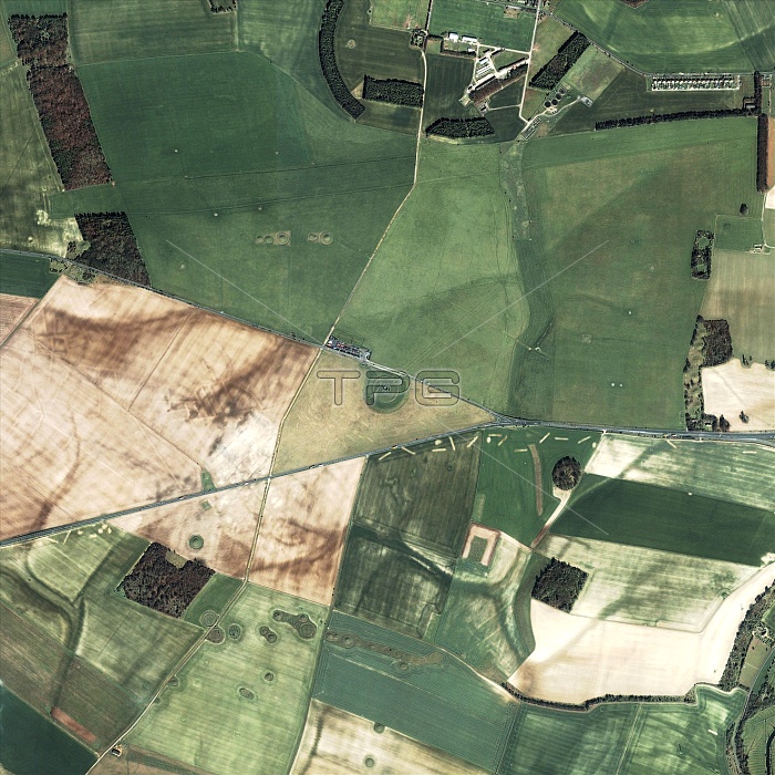
Stonehenge, United Kingdom, satellite image. North is at top. Stonehenge, a circle of standing stones on Salisbury Plain, is at centre, surrounded by fields and roads. Some of the stones were erected around 2000 BC by a Stone Age civilisation known as the Beaker culture. It is thought that the alignment of the standing stones was planned so that sunlight would shine on particular areas on important astronomical dates, such as the summer solstice, the longest day of the year. Image obtained by the Ikonos satellite on 27 March 2002.
| px | px | dpi | = | cm | x | cm | = | MB |
Details
Creative#:
TOP10236178
Source:
達志影像
Authorization Type:
RM
Release Information:
須由TPG 完整授權
Model Release:
N/A
Property Release:
N/A
Right to Privacy:
No
Same folder images:
STONEHENGEHENGESTONECIRCLEMONUMENTTOURISTATTRACTIONANCIENTOBSERVATORYSOLARALIGNMENTSALISBURYPLAINENGLANDUKEUROPEGEOGRAPHYHISTORYEARTHOBSERVATIONARCHAEOLOGYARCHAEOASTRONOMYANCIENTASTRONOMYASTRONOMYSATELLITEIMAGEFROMSPACEIKONOSSATELLITESQUARE2000BC2NDMILLENNIUMBCSTONEAGEPREHISTORY200221STCENTURYARCHAEASTRONOMYOBSERVATORYHISTORICALASTRONOMICALARCHAEOLOGICALALIGNMENTSSOLSTICESOLSTICESEQUINOXEQUINOXESANCIENTOBSERVATORIESSOLARASTRONOMYRELIGIONRELIGIOUSCEREMONYCEREMONIALTOURISMGEOGRAPHICALEUROPEANUNITEDKINGDOMBRITAINBRITISHENGLISHNEOLITHICBEAKERCULTUREPEOPLEPREHISTORICSTANDINGSTONESTANDINGSTONESRINGCIRCLEMEGALITHMONOLITHMEGALITHICMONOLITHICFIELDS"
"2000200221ST2NDAGEALIGNMENTALIGNMENTSANCIENTANCIENTANCIENTARCHAEASTRONOMYARCHAEOASTRONOMYARCHAEOLOGICALARCHAEOLOGYASTRONOMICALASTRONOMYASTRONOMYASTRONOMYATTRACTIONBCBCBEAKERBRITAINBRITISHCENTURYCEREMONIALCEREMONYCIRCLECIRCLECULTUREEARTHENGLANDENGLISHEQUINOXEQUINOXESEUROPEEUROPEANFIELDSFROMGEOGRAPHICALGEOGRAPHYHENGEHISTORICALHISTORYIKONOSIMAGEKINGDOMMEGALITHMEGALITHICMILLENNIUMMONOLITHMONOLITHICMONUMENTNEOLITHICOBSERVATIONOBSERVATORIESOBSERVATORYOBSERVATORYPEOPLEPLAINPREHISTORICPREHISTORYRELIGIONRELIGIOUSRINGSALISBURYSATELLITESATELLITESOLARSOLARSOLSTICESOLSTICESSPACESQUARESTANDINGSTANDINGSTONESTONESTONESTONEHENGESTONESTOURISMTOURISTUKUNITED
 Loading