
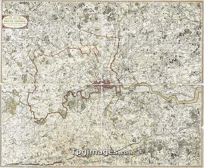
18th Century map of London. Hand coloured historical map showing an area twenty-five miles round London. North is at top. The map stretches from Windsor (far left) in the West, to Basildon (far right) in the East. And from Ware, Hertfordshire, in the North to Dorking in the south. Westminster and Southwark (dark areas, centre) can be seen along the north and south banks of the River Thames respectively, with Hyde Park to the West and the Greenwich peninsular to the East of the City. This map was drawn in 1790 by William Faden.
| px | px | dpi | = | cm | x | cm | = | MB |
Details
Creative#:
TOP06673158
Source:
達志影像
Authorization Type:
RM
Release Information:
須由TPG 完整授權
Model Release:
NO
Property Release:
NO
Right to Privacy:
No
Same folder images:
cityeuropeuklondoncityofwestminstersouthwarkgeographyhistorycartographyartworkillustrationhand-coloured18thcentury1700s1790areaaroundlondonboroughboroughsbritishbritishempirecapitalcitycentrallondoncityoflondonearthscienceeastenglisheuropeangeographicalgreaterlondongreenwichpeninsularhistorichistoricalisleofdogsmappingmapsnortholdoutskirtsplanriverriverthamessciencessouthstreetstreetssurveytoweroflondonunitedkingdomurbanurbanenvironmenturbanisationwaterwestwestminsterwilliamfadenbritain"
"1700s179018thareaaroundartworkboroughboroughsbritainbritishbritishcapitalcartographycentralcenturycitycitycitycitydogseartheastempireenglishenvironmenteuropeeuropeanfadengeographicalgeographygreatergreenwichhand-colouredhistorichistoricalhistoryillustrationislekingdomlondonlondonlondonlondonlondonlondonmappingmapsnorthofofofofoldoutskirtspeninsularplanriverriversciencesciencessouthsouthwarkstreetstreetssurveythamestowerukunitedurbanurbanurbanisationwaterwestwestminsterwestminsterwilliam
 Loading