
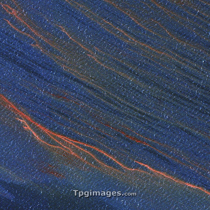
Gulf of Mexico oil spill, 2010. Satellite image of a portion of the oil spill (brown) caused by the explosion of the Deepwater Horizon oil rig in the Gulf of Mexico 20th April 2010. Over five thousand barrels of oil a day leaked into the Gulf of Mexico, 80 kilometres from the coast of Louisiana, USA, harming local wildlife and fishing industries. Image taken by the GeoEye-1 satellite on 29th April 2010.
| px | px | dpi | = | cm | x | cm | = | MB |
Details
Creative#:
TOP06665846
Source:
達志影像
Authorization Type:
RM
Release Information:
須由TPG 完整授權
Model Release:
NO
Property Release:
NO
Right to Privacy:
No
Same folder images:
oilspillnorthamericausagulfofmexicopollutingspillingindustryenvironmentalsciencesatelliteimagesatellitegeoeye-121stcentury29april2010accidentamericanbpcontaminatedcontaminationdamagedamageddeepwaterhorizondisasterdrillingrigexplosionfromspacehumanimpactindustrialoilplatformoilrigpollutedpollutionseaslickunitedstatesuswater"
"201021st29accidentamericaamericanaprilbpcenturycontaminatedcontaminationdamagedamageddeepwaterdisasterdrillingenvironmentalexplosionfromgeoeye-1gulfhorizonhumanimageimpactindustrialindustrymexiconorthofoiloiloilplatformpollutedpollutingpollutionrigrigsatellitesatellitescienceseaslickspacespillspillingstatesunitedususawater
 Loading