
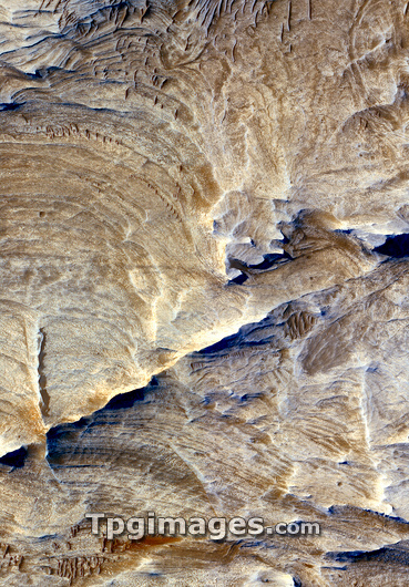
Fluvial erosion on Mars. Satellite image of the Candor Chasma region of the Valles Marineris canyon. It is thought that this canyon initially formed as the result of tectonic fracturing of the upper crust of Mars. The ridged areas on the valley floor are intepretated as being joints that were exposed during subsequent fluvial erosion (erosion by flowing water). This image was obtained by the High Resolution Imaging Science Experiment (HiRise) camera on board the Mars Reconnaissance Orbiter, December 2, 2006.
| px | px | dpi | = | cm | x | cm | = | MB |
Details
Creative#:
TOP03224290
Source:
達志影像
Authorization Type:
RM
Release Information:
須由TPG 完整授權
Model Release:
N/A
Property Release:
N/A
Right to Privacy:
No
Same folder images:
MARSJOINTFRACTURERIDGEVALLEYCANYONPLANETSPACESOLARSYSTEMVALLESMARINERISCANDORCHASMAPLANETARYSIENCEAREOLOGYGEOLOGYSATELLITEIMAGEHIRISESATELLITE21STCENTURY2006DECEMBER2006/12/2WATERLAYERSROCKOUTCROPSNASAMARTIANSEDIMENTARYDEPOSITIONORBITERCAMERAGEOMORPHOLOGYHYDROLOGYASTRONOMYCOSMOLOGYSCIENCEMARSPLANETARYASTRONOMYCOSMOLOGYSCIENCEMARSPLANETARYGEOLOGICALFROMSPACEHIGHRESOLUTIONIMAGINGSCIENCEEXPERIMENTMARSRECONNAISANCEORBITERTERRAINRIDGEDRIDGESEROSIONERODEDMROMARSRECONNAISSANCEORBITER
20062006/12/221STAREOLOGYASTRONOMYASTRONOMYCAMERACANDORCANYONCENTURYCHASMACOSMOLOGYCOSMOLOGYDECEMBERDEPOSITIONERODEDEROSIONEXPERIMENTFRACTUREFROMGEOLOGICALGEOLOGYGEOMORPHOLOGYHIGHHIRISEHYDROLOGYIMAGEIMAGINGJOINTLAYERSMARINERISMARSMARSMARSMARSMARSMARTIANMRONASAORBITERORBITERORBITEROUTCROPSPLANETPLANETARYPLANETARYPLANETARYRECONNAISANCERECONNAISSANCERESOLUTIONRIDGERIDGEDRIDGESROCKSATELLITESATELLITESCIENCESCIENCESCIENCESEDIMENTARYSIENCESOLARSPACESPACESYSTEMTERRAINVALLESVALLEYWATER
 Loading