
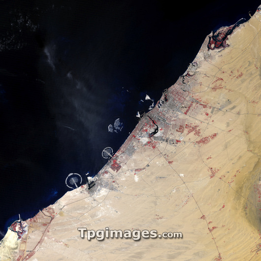
Dubai, 2006, satellite image. North is at top. Water is dark blue, urbanized areas grey, vegetated areas are red and desert is light brown. Dubai is one of the seven emirates in the United Arab Emirates (UAE), which formed in 1971. Dubai City is situated on the banks of Dubai Creek, (centre) a natural inlet used for shipping. Jebel Ali, the world's largest man made harbour, is situated further west (lower left). Dubai saw major economic growth after the discovery of reserves of oil in the late 1960s. It began to develop its tourism and real estate industry after 2000, when construction of the artificial Palm Islands (lower left) and the World Archipelago (centre) developments began. To compare earlier images of Dubai see E780/1456, and E780/1457. This image was obtained on 11/10/06, by Landsat 1.
| px | px | dpi | = | cm | x | cm | = | MB |
Details
Creative#:
TOP03209632
Source:
達志影像
Authorization Type:
RM
Release Information:
須由TPG 完整授權
Model Release:
N/A
Property Release:
N/A
Right to Privacy:
No
Same folder images:
 Loading