
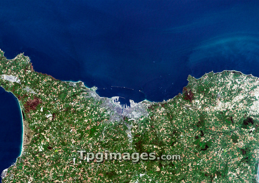
Cherbourg-Octeville, France, satellite image. North is at top, water is blue, urban areas are grey and vegetation is green. Cherbourg-Octeville was once two separate cities. It was formed when Cherbourg merged with Octeville and was officially renamed Cherbourg-Octeville in 2000. It is located at the north of the Cotentin Peninsula (also known as the Cherbourg Peninsula), in the Basse- Normandie (Lower Normandy) region, northwest France. The Cotentin Peninsula extends out into the English Channel. Photographed on 12th May 2001.
| px | px | dpi | = | cm | x | cm | = | MB |
Details
Creative#:
TOP03209509
Source:
達志影像
Authorization Type:
RM
Release Information:
須由TPG 完整授權
Model Release:
N/A
Property Release:
N/A
Right to Privacy:
No
Same folder images:
OCTEVILLECHERBOURGCHERBOURG-OCTEVILLEPORTTOWNCITYFRANCEEUROPEGEOGRAPHYEARTHOBSERVATIONSATELLITEIMAGEFROMSPACESATELLITESPRINGMAY2001/5/1221STCENTURYEUROPEANFRENCHGEOGRAPHICALCITIESURBANISATIONURBANIZATIONURBANNORMANDYCOMMUNENORTHWESTFRANCENORTH-WESTCOTENTINPENINSULACHERBOURGPENINSULAMANCHEBASSE-NORMANDIEENGLISHCHANNELLOWERNORMANDY
2001/5/1221STBASSE-NORMANDIECENTURYCHANNELCHERBOURGCHERBOURGCHERBOURG-OCTEVILLECITIESCITYCOMMUNECOTENTINEARTHENGLISHEUROPEEUROPEANFRANCEFRANCEFRENCHFROMGEOGRAPHICALGEOGRAPHYIMAGELOWERMANCHEMAYNORMANDYNORMANDYNORTH-WESTNORTHWESTOBSERVATIONOCTEVILLEPENINSULAPENINSULAPORTSATELLITESATELLITESPACESPRINGTOWNURBANURBANISATIONURBANIZATION
 Loading