
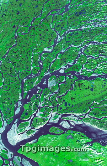
Lena River Delta. Satellite image of part of the delta of the Lena River. North is at top. Water is blue and wetland areas are green. This river flows 4400 kilometres from south-central Russia, to this delta on the Arctic coast of north-west Russia. At the delta, the water spreads out through numerous channels, depositing its silt to build the land of the delta, before emptying into the Laptev Sea. The delta is frozen in the winter, but in summer it is a thriving wetland. Image data obtained on 16 July 2005, with the ASTER instrument on the Terra satellite.
| px | px | dpi | = | cm | x | cm | = | MB |
Details
Creative#:
TOP03208440
Source:
達志影像
Authorization Type:
RM
Release Information:
須由TPG 完整授權
Model Release:
N/A
Property Release:
N/A
Right to Privacy:
No
Same folder images:
LENALENADELTALENARIVERSWAMPWETLANDDELTARIVERLAPTEVSEACOASTRUSSIAEUROPEECOLOGYEARTHOBSERVATIONGEOGRAPHYSATELLITEIMAGEFROMSPACEASTERSATELLITETERRA16THJULY2005SUMMER200521STCENTURY2005/7/1616-Jul-05ENVIRONMENTGEOGRAPHICALEUROPEANECOLOGICALNATURECOASTALMARSHMARSHESSILTSEDIMENTRUSSIANADVANCEDSPACEBORNETHERMALEMISSIONANDREFLECTIONRADIOMETERENVIRONMENTAL
16-Jul-0516TH200520052005/7/1621STADVANCEDANDASTERCENTURYCOASTCOASTALDELTADELTAEARTHECOLOGICALECOLOGYEMISSIONENVIRONMENTENVIRONMENTALEUROPEEUROPEANFROMGEOGRAPHICALGEOGRAPHYIMAGEJULYLAPTEVLENALENALENAMARSHMARSHESNATUREOBSERVATIONRADIOMETERREFLECTIONRIVERRIVERRUSSIARUSSIANSATELLITESATELLITESEASEDIMENTSILTSPACESPACEBORNESUMMERSWAMPTERRATHERMALWETLAND
 Loading