
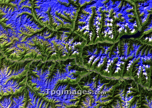
Eastern Himalayas, satellite image. North is at top. Cloud cover is white. The snow-capped peaks are dark blue, the lower slopes are covered by vegetation (dark green). Areas of barren earth (including the valley bottom) are light green. A large lake is at top right (indigo). This image has been achieved using thematic mapper (TM) instrumentation. The TM sensor collects radiometric data in seven spectral bands. Each band gathers particular information on different surface features. The bands are combined to achieve a particular image. This image was achieved using Bands: 3, for discrimination of vegetation types, 5, to differentiate between cloud and snow and for determination of soil and vegetation moisture content, and 7, for discrimination of rock types. These bands have a spectral range of 0.63 to 2.35 micrometres.
| px | px | dpi | = | cm | x | cm | = | MB |
Details
Creative#:
TOP03208334
Source:
達志影像
Authorization Type:
RM
Release Information:
須由TPG 完整授權
Model Release:
N/A
Property Release:
N/A
Right to Privacy:
No
Same folder images:
 Loading