
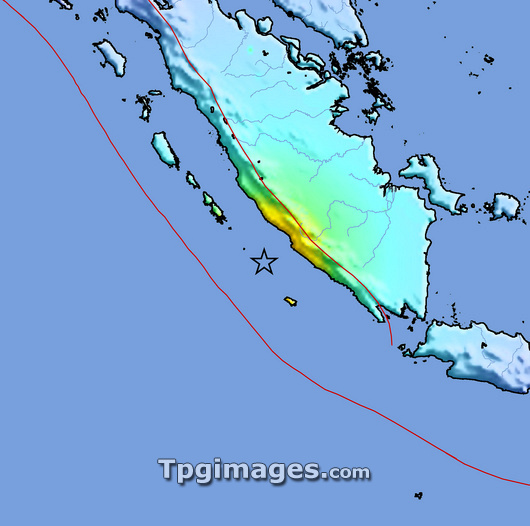
2007 Sumatra earthquake intensity map. This earthquake struck at 18.10 local time on 12th September 2007 on the Indonesian island of Sumatra and had a magnitude of 8.2. The earthquake caused buildings to collapse on the west coast of Sumatra, Indonesia, and injured hundreds of people. The Pacific Tsunami Warning Centre issued an alert for the entire Indian Ocean region. The epicentre (marked by the black star) was 30 kilometres below the seabed to the west of Sumatra. The colours on the land show the intensity of the shaking felt, from orange (severe) through yellow (strong) and green (moderate) to blue (weak). The red line diagonally across centre is the fault line between the Indo-Australian and the Sunda tectonic plates.
| px | px | dpi | = | cm | x | cm | = | MB |
Details
Creative#:
TOP03207379
Source:
達志影像
Authorization Type:
RM
Release Information:
須由TPG 完整授權
Model Release:
N/A
Property Release:
N/A
Right to Privacy:
No
Same folder images:
 Loading