
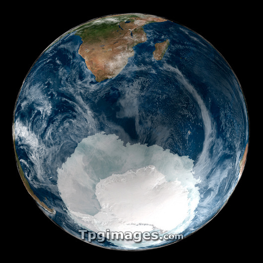
Antarctic ice sheet. Composite satellite image of the Earth showing the extent of sea ice surrounding Antarctica at its winter maximum. The Antarctic ice sheet covers Antarctica and parts of the surrounding oceans. The boundary of the land mass can be discerned by the difference in shade of white. September is the end of winter in Antarctica, the ice shelves which surround its land mass are at their most extensive at this time of year. Data collected by the Terra and Aqua satellites.
| px | px | dpi | = | cm | x | cm | = | MB |
Details
Creative#:
TOP03206978
Source:
達志影像
Authorization Type:
RM
Release Information:
須由TPG 完整授權
Model Release:
N/A
Property Release:
N/A
Right to Privacy:
No
Same folder images:
EARTHICECAPPLANETICEGLOBESOUTHPOLEANTARCTICACLIMATOLOGYGEOGRAPHYCOMPOSITESATELLITEIMAGEAQUATERRAWINTER21STCENTURY200521SEPTEMBERNORTHAMERICANGEOGRAPHICALCLIMATOLOGICALFROMSPACEBLUEMARBLENEXTGENERATIONSEASONALSOUTHERNHEMISPHEREGLACIATIONENVIRONMENTCUT-OUTCUTOUTSECOND-LOWESTGLOBALWARMINGCLIMATECHANGEPOLARICECAPCOVERSHEETEXTENTICESHELFSHELVESACCRETIONARYMAXIMUM
21200521STACCRETIONARYAMERICANANTARCTICAAQUABLUECAPCAPCENTURYCHANGECLIMATECLIMATOLOGICALCLIMATOLOGYCOMPOSITECOVERCUT-OUTCUTOUTEARTHENVIRONMENTEXTENTFROMGENERATIONGEOGRAPHICALGEOGRAPHYGLACIATIONGLOBALGLOBEHEMISPHEREICEICEICEICEIMAGEMARBLEMAXIMUMNEXTNORTHPLANETPOLARPOLESATELLITESEASONALSECOND-LOWESTSEPTEMBERSHEETSHELFSHELVESSOUTHSOUTHERNSPACETERRAWARMINGWINTER
 Loading