
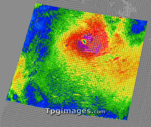
Tropical Cyclone Dora. Wind speed data map for Tropical Cyclone Dora at 13:20 UTC on 5 February 2007. The wind speeds are colour-coded, with the maximum gusts (purple) reaching speeds of over 50 kilometres per hour (kph) at the centre of the cyclone. The speeds are lower further out from the centre: red (30kph), yellow (20kph), green (15kph) and blue (10kph). A cyclone is the name for the cyclonic storms that form in the Indian and western Pacific oceans, the equivalent of hurricanes in the Atlantic. At this point, Dora was a weak Category 4 cyclone near Rodrigues Island (left of the cyclone's eye) in the southern Indian Ocean. Image data obtained by the SeaWinds Scatterometer on NASA's QuikSCAT satellite.
| px | px | dpi | = | cm | x | cm | = | MB |
Details
Creative#:
TOP03206845
Source:
達志影像
Authorization Type:
RM
Release Information:
須由TPG 完整授權
Model Release:
N/A
Property Release:
N/A
Right to Privacy:
No
Same folder images:
 Loading