
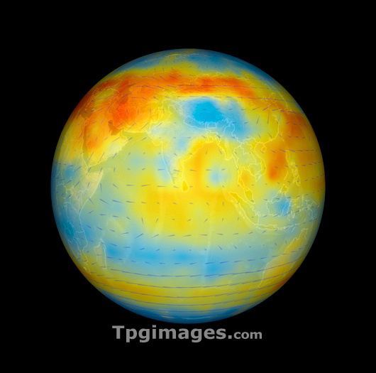
Atmospheric carbon dioxide levels centred on Asia, satellite data. Carbon dioxide (CO2) is a greenhouse gas that contributes to global warming. CO2 levels vary from low (blue, 360 parts per million) through medium (yellow and orange) to high (red, 385 parts per million). Wind directions (arrows) are also shown. The CO2 levels were measured in the mid-troposphere, around eight kilometres above the Earth's surface. The levels are highest above industrialised areas (Europe, Central Asia and the Pacific Rim) that produce CO2, and lowest over uninhabited or elevated areas (the Himalayas and Tibet). This image is based on data acquired in July 2003 by the Atmospheric Infrared Sounder (AIRS) instrument on NASA's Aqua satellite.
| px | px | dpi | = | cm | x | cm | = | MB |
Details
Creative#:
TOP03206578
Source:
達志影像
Authorization Type:
RM
Release Information:
須由TPG 完整授權
Model Release:
N/A
Property Release:
N/A
Right to Privacy:
No
Same folder images:
 Loading