
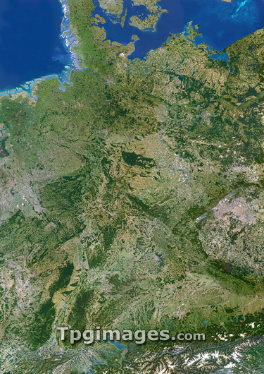
Germany, satellite image. North is at top. Green area are vegetated. White areas are ice. This area covers Germany (centre) and its borders with Poland, Czech Republic and Austria (east). Switzerland (south) and France, Luxembourg, Belgium and the Netherlands (west). Denmark is the peninsula to the north with the North Sea to the west and the Baltic Sea to the east. Germany's capital city, Berlin, is visible in the upper right (grey area). The mountain range in the south is the Bavarian Alps.
| px | px | dpi | = | cm | x | cm | = | MB |
Details
Creative#:
TOP03206510
Source:
達志影像
Authorization Type:
RM
Release Information:
須由TPG 完整授權
Model Release:
N/A
Property Release:
N/A
Right to Privacy:
No
Same folder images:
GERMANYCOUNTRYEARTHEUROPEGEOGRAPHYEARTHOBSERVATIONSATELLITEIMAGEFROMSPACECOMPOSITESATELLITEGERMANEUROPEANGEOGRAPHICALEARTHSCIENCESCIENCESIMAGEIMAGESPHOTOPHOTOSFROMSPACETOPOGRAPHYCARTOGRAPHYALPSNETHERLANDSBELGIUMLUXEMBOURGFRANCEFRENCHSWITZERLANDAUSTRIACZECHREPUBLICPOLANDMOUNTAINSNORTHSEABALTICSEADENMARK
ALPSAUSTRIABALTICBELGIUMCARTOGRAPHYCOMPOSITECOUNTRYCZECHDENMARKEARTHEARTHEARTHEUROPEEUROPEANFRANCEFRENCHFROMFROMGEOGRAPHICALGEOGRAPHYGERMANGERMANYIMAGEIMAGEIMAGESLUXEMBOURGMOUNTAINSNETHERLANDSNORTHOBSERVATIONPHOTOPHOTOSPOLANDREPUBLICSATELLITESATELLITESCIENCESCIENCESSEASEASPACESPACESWITZERLANDTOPOGRAPHY
 Loading