
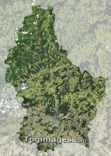
Luxembourg, satellite image. North is at top. Green areas are vegetated. Grey areas are urbanized. Luxembourg is bordered by Germany to the east, France to the south and Belgium to the west and north. Its eponymous capital city is located in the south of the country. The large wooded area to the north is the sparsely populated Oesling. This forms part of the international Ardennes region of forests.
| px | px | dpi | = | cm | x | cm | = | MB |
Details
Creative#:
TOP03206504
Source:
達志影像
Authorization Type:
RM
Release Information:
須由TPG 完整授權
Model Release:
N/A
Property Release:
N/A
Right to Privacy:
No
Same folder images:
LUXEMBOURGCOUNTRYEARTHEUROPEANUNIONEUROPEPOLITICSGEOGRAPHYEARTHOBSERVATIONSATELLITEIMAGEFROMSPACECOMPOSITESATELLITEEUROPEANGEOGRAPHICALEARTHSCIENCESCIENCESNATIONNATIONSCOUNTRYCOUNTRIESFROMSPACECARTOGRAPHYTOPOGRAPHYBORDERBORDERSVEGETATIONLUXEMBOURGCITYGERMANYGERMANFRANCEFRENCHBELGIUMLANDLOCKEDOESLINGARDENNESBENELUX
ARDENNESBELGIUMBENELUXBORDERBORDERSCARTOGRAPHYCITYCOMPOSITECOUNTRIESCOUNTRYCOUNTRYEARTHEARTHEARTHEUROPEEUROPEANEUROPEANFRANCEFRENCHFROMFROMGEOGRAPHICALGEOGRAPHYGERMANGERMANYIMAGELANDLOCKEDLUXEMBOURGLUXEMBOURGNATIONNATIONSOBSERVATIONOESLINGPOLITICSSATELLITESATELLITESCIENCESCIENCESSPACESPACETOPOGRAPHYUNIONVEGETATION
 Loading