
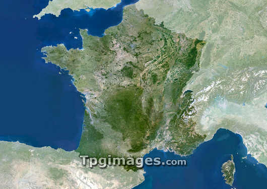
France, satellite image. North is at top. Green areas are vegetated. Grey areas are urban. White areas are ice. France's capital city, Paris, can be seen to the north of middle image. France is bordered by Belgium in the north, Germany, Switzerland and Italy in the east. In the southeast are the French Alps. To the south of France is the Mediterranean Sea and in the southwest is the border with Spain. In the west France borders the Bay of Biscay and the English Channel.
| px | px | dpi | = | cm | x | cm | = | MB |
Details
Creative#:
TOP03206502
Source:
達志影像
Authorization Type:
RM
Release Information:
須由TPG 完整授權
Model Release:
N/A
Property Release:
N/A
Right to Privacy:
No
Same folder images:
FRANCECOUNTRYEARTHEUROPEANUNIONEUROPEPOLITICSGEOGRAPHYEARTHOBSERVATIONSATELLITEIMAGEFROMSPACECOMPOSITESATELLITEFRENCHEUROPEANGEOGRAPHICALEARTHSCIENCESCIENCESNATIONNATIONSBRITISHCOUNTRYCOUNTRIESFROMSPACEPARISALPSFRENCHALPSMEDITERRANEANBAYOFBISCAYUKUNITEDKINGDOMBRITAINSPAINBELGIUMGERMANYGERMANSWITZERLANDITALYTOPOGRAPHYCARTOGRAPHYEUBORDERBORDERS
ALPSALPSBAYBELGIUMBISCAYBORDERBORDERSBRITAINBRITISHCARTOGRAPHYCOMPOSITECOUNTRIESCOUNTRYCOUNTRYEARTHEARTHEARTHEUEUROPEEUROPEANEUROPEANFRANCEFRENCHFRENCHFROMFROMGEOGRAPHICALGEOGRAPHYGERMANGERMANYIMAGEITALYKINGDOMMEDITERRANEANNATIONNATIONSOBSERVATIONOFPARISPOLITICSSATELLITESATELLITESCIENCESCIENCESSPACESPACESPAINSWITZERLANDTOPOGRAPHYUKUNIONUNITED
 Loading