
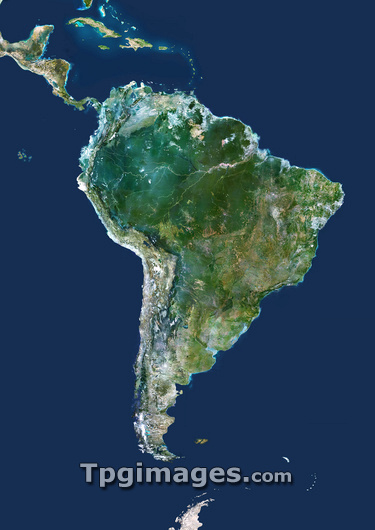
South America, satellite image. North is at top. Green areas are vegetated. Yellow areas are desert. The Andes mountain range (grey area) runs the full length of the western side of South America. In northern South America, east of the Andes is the Amazon Rainforest. This is the largest area of rainforest in the world. To the north of South America is the Caribbean and Central America. To the east is the Atlantic Ocean. In the south, the tip of the Antarctic Peninsula is visible. The west coast of South America is bounded by the Pacific Ocean.
| px | px | dpi | = | cm | x | cm | = | MB |
Details
Creative#:
TOP03206434
Source:
達志影像
Authorization Type:
RM
Release Information:
須由TPG 完整授權
Model Release:
N/A
Property Release:
N/A
Right to Privacy:
No
Same folder images:
PACIFICOCEANATLANTICOCEANCARIBBEANCENTRALAMERICASOUTHAMERICAOCEANCONTINENTEARTHEARTHOBSERVATIONGEOGRAPHYCOMPOSITESATELLITEIMAGEFROMSPACESATELLITEGEOGRAPHICALEARTHSCIENCESCIENCESIMAGEIMAGESPHOTOPHOTOSFROMSPACETOPOGRAPHYCARTOGRAPHYSEAICEICECAPICECAPISLANDSISLANDCARIBBEANSEASOUTHAMERICANSOUTHERNHEMISPHEREFALKLANDISLANDSANTARCTICAANTARCTICPENINSULAAMAZONBASINAMAZONRAINFORESTANDESMOUNTAINSRAINFOREST
AMAZONAMAZONAMERICAAMERICAAMERICANANDESANTARCTICANTARCTICAATLANTICBASINCAPCARIBBEANCARIBBEANCARTOGRAPHYCENTRALCOMPOSITECONTINENTEARTHEARTHEARTHFALKLANDFROMFROMGEOGRAPHICALGEOGRAPHYHEMISPHEREICEICEICECAPIMAGEIMAGEIMAGESISLANDISLANDSISLANDSMOUNTAINSOBSERVATIONOCEANOCEANOCEANPACIFICPENINSULAPHOTOPHOTOSRAINFORESTRAINFORESTSATELLITESATELLITESCIENCESCIENCESSEASEASOUTHSOUTHSOUTHERNSPACESPACETOPOGRAPHY
 Loading