
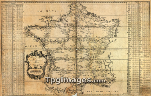
Map of France, published in 1744 by Jacques Phillipe Maraldi and Cesar Francois Cassini de Thury. This map was based on triangulation surveys and was the first accurate national topographical map of the country. It showed France to be 10 per cent larger than previously thought. The map, which comprised 18 sheets, took three generations of the Cassini family to complete.
| px | px | dpi | = | cm | x | cm | = | MB |
Details
Creative#:
TOP03206400
Source:
達志影像
Authorization Type:
RM
Release Information:
須由TPG 完整授權
Model Release:
N/A
Property Release:
N/A
Right to Privacy:
No
Same folder images:
FRANCEMAPCOUNTRYEUROPEGEOGRAPHYHISTORYCARTOGRAPHYSEPIAMONOCHROME1740S174418THCENTURYFRENCHEUROPEANHISTORICALGEOGRAPHICAL1700SEARTHSCIENCESCIENCESHISTORICALHISTORYMAPPINGMAPSOLDANCIENTMAPCARTOGRAPHYTRIANGULATIONNATIONALFIRSTJACQUESPHILIPPEMARALDICESARFRANCOISCASSINIDETHURYTOPOGRAPHICALTOPOGRAPHYGEOMETRICGEOMETRICALSCRUFFYTATTERED
1700S1740S174418THANCIENTCARTOGRAPHYCARTOGRAPHYCASSINICENTURYCESARCOUNTRYDEEARTHEUROPEEUROPEANFIRSTFRANCEFRANCOISFRENCHGEOGRAPHICALGEOGRAPHYGEOMETRICGEOMETRICALHISTORICALHISTORICALHISTORYHISTORYJACQUESMAPMAPMAPPINGMAPSMARALDIMONOCHROMENATIONALOLDPHILIPPESCIENCESCIENCESSCRUFFYSEPIATATTEREDTHURYTOPOGRAPHICALTOPOGRAPHYTRIANGULATION
 Loading