
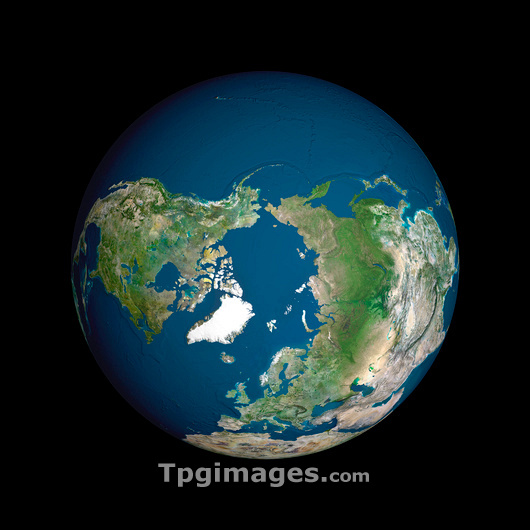
Earth. Computer artwork, based on satellite data of the Earth from space. Green shows vegetated areas. Yellow shows desert areas. White shows ice. This image is centred on the Arctic Ocean. Much of the Arctic is covered with sea ice during winter months. The North Pole lies within the Arctic Ocean and is the world's most northerly point. The Arctic Ocean is bounded by land on most sides. Top is the Pacific Ocean. Right is Asia. Lower left is the Greenland ice cap (white). Europe and Africa are at bottom. Left is North America.
| px | px | dpi | = | cm | x | cm | = | MB |
Details
Creative#:
TOP03206298
Source:
達志影像
Authorization Type:
RM
Release Information:
須由TPG 完整授權
Model Release:
N/A
Property Release:
N/A
Right to Privacy:
No
Same folder images:
ARCTICOCEANARCTICASIAEUROPEATLANTICOCEANPACIFICOCEANAFRICAEARTHICECAPSEAOCEANCONTINENTPLANETSPACESOLARSYSTEMEARTHOBSERVATIONGEOGRAPHYSATELLITEIMAGEFROMSPACECOMPOSITECOMPUTERARTWORKSPHERICALSPHEREGLOBEROUNDBALLAFRICANGEOGRAPHICALILLUSTRATIONEARTHSCIENCESCIENCESPHOTOPHOTOSIMAGEIMAGESCARTOGRAPHYTOPOGRAPHYWATERVEGETATIONICECOLDFROZENPOLENORTHARCTICCIRCLEMOSTNORTHERLYPOINTEUROPEANASIANNORTHERNHEMISPHEREGREENLANDNORTHAMERICANORTHAMERICAN
AFRICAAFRICANAMERICAAMERICANARCTICARCTICARCTICARTWORKASIAASIANATLANTICBALLCAPCARTOGRAPHYCIRCLECOLDCOMPOSITECOMPUTERCONTINENTEARTHEARTHEARTHEUROPEEUROPEANFROMFROZENGEOGRAPHICALGEOGRAPHYGLOBEGREENLANDHEMISPHEREICEICEILLUSTRATIONIMAGEIMAGEIMAGESMOSTNORTHNORTHNORTHNORTHERLYNORTHERNOBSERVATIONOCEANOCEANOCEANOCEANPACIFICPHOTOPHOTOSPLANETPOINTPOLEROUNDSATELLITESCIENCESCIENCESSEASOLARSPACESPACESPHERESPHERICALSYSTEMTOPOGRAPHYVEGETATIONWATER
 Loading