
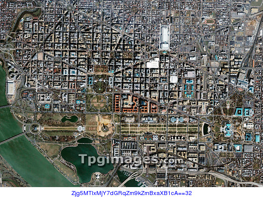
Washington DC. Satellite image of Washington DC, the capital city of the USA. The area seen here is mostly government buildings, museums, monuments and other landmarks. The Potomac River is seen at bottom left. The strip across bottom is the area known as the National Mall. It runs from the Abraham Lincoln Memorial (left) to the government buildings of the Capitol area (right). Just left of the centre of the Mall, surrounded by a brown patch, is the Washington Monument. The White House is just above that, at centre left. Image taken by the Ikonos satellite on 6 April 2004.
| px | px | dpi | = | cm | x | cm | = | MB |
Details
Creative#:
TOP01491270
Source:
達志影像
Authorization Type:
RM
Release Information:
須由TPG 完整授權
Model Release:
N/A
Property Release:
N/A
Right to Privacy:
No
Same folder images:
 Loading